Aragats – a hike to Armenian 4,000m high mountain
The highest mountain in Armenia can be found at an altitude of 4,090m, which is incredibly high compared to the Czech highest mountain (Sněžka), so many would be frightened in advance and give it up. But that would be a shame. Climbing Aragats is a great experience, even though it´s demanding. Moreover, Aragats is not only one peak, but consists of 4 separate peaks, among which there is a huge crater. So you can choose which of the peaks to climb, and if you are in a really good shape, you can manage all four. In addition to a great feeling of conquering a four-thousand mountain, you will enjoy breath-taking views as far as of Yerevan and the biblical Mount Ararat on the border with Turkey, which is still an incredible 1,000 meters higher.
Obsah článku

Let me start with some information about the mountain itself and its origin. Aragats is an extinct volcano with a crater about 350m deep and 2km wide. Around it, 4 peaks rise – north (4090m), west (3995m), east (3910m) and south (3890m). On the northern slope of the mountain rises the Kasaghriver, which flows mostly along its eastern foot. Aragats is a popular tourist destination. On the one hand, it is located only 60km from the capital Yerevan and, on the other, it is not extremely physically demanding to climb it. I hadn´t found much information when planning our trip, so I will first try to summarize the most important, and then I will describe the whole trek.
Useful information
Name: Mount Aragats (English), Արագած (Armenian), Aragac (Czech)
When to go: the best months to climb are June to August, the rest of the year the weather might be bad with large layer of snow. Even in the summer months, however, beware of changes in weather. Sudden fogs, frequent thunderstorms and rains are not uncommon and during the trek there is noplace to hide. The sooner you set out in the morning, the better, because around noon the sky usually gets cloudy and wind begins to blow uncomfortably.
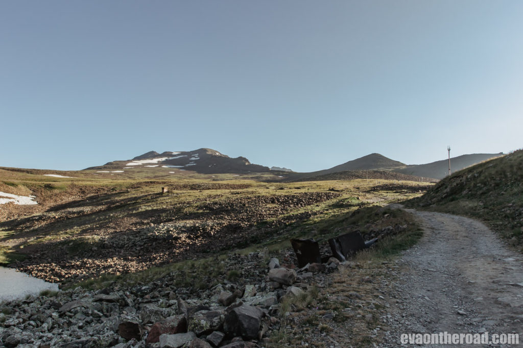
How to get there: the trek begins at Kar’i Lich Lake at an altitude of 3,190m, which can be reached on an asphalt road in summer. Unfortunately, there is no public transport to the lake, so you will need your own car or taxi. For a taxi from Yerevan you should pay around 6,000 ADM (use the Bolt app), car rental costs from 30 EUR / day. The last option is to travel by marshrutfrom Yerevan to Byurakanand arrange a driver there who will take you to the lake. Or you can try hitchhiking. There is quite a lot of traffic on the road, so you might be lucky.
Accommodation: there is a restaurant with a hotel on the lake, but it is not offered anywhere on the Internet. If you ask the staff, they will offer you a room. It costs 20,000 ADM (almost 1,000CZK) for 2 people and the rooms are said to be musty (verified information from Czechs who slept there at the same time as I was there). You can also sleep in your car in the car park next to the lake or in your own tent nearby. Those who are only going to the southern or western peak can leave from Yerevan early in the morning. It is a 2-hour drive. The last option and the one we chose, is to stay in Byurakan and drive 25km to the lake in the morning. We slept at Seva Guesthouse (46 street House 3) for 12,000 AMD (less than 600 CZK) and even at 6 in the morning we got a huge breakfast.
Food & Drink: There is no shelter from the lake to the peaks, no possibility to refill drinking water or food supplies. You have to take everything with you.
How much it costs: there are no fees
How long the ascent takes: ascent to the southern (lowest) peak takes 2-3 hours, you will return a little shorter. Add another 1.5 hour to reach the western summit. Keep 13 hours to the northern (highest) summit and back. Keep in mind that climbing to all 4 peaks in a single day is very demanding and requires great physical shape.
Difficulty: medium. You may experience difficulties with altitude and rocky terrain, but otherwise you will reach the lowest peak at least normally. It is recommended that you stay overnight at the lake to acclimatize yourself. We slept in the foothills and had no trouble.
Equipment: if you go in summer, you don’t need any special equipment for the southern and western peaks, but do not go in sneakers or trekking sandals (yes, we have seen such cases). You will walk over large and then crumbling stones, so good footwear is necessary. We did not reach the northern peak, but no special climbing equipment should be necessary there either. In July, the snow was at the bottom of the crater, at the tops only in a few places.
Trek
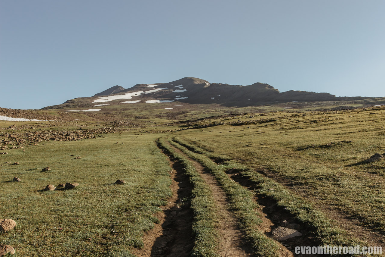
We arrived at the lake after 7 am, but we could have been there an hour earlier. Getting up is our classic problem. The sooner you start the better. In the morning, visibility is good and no wind blows. The path to the summit is not marked, but it is beaten and obvious. Plus, you won’t be alone on the trek, so don’t worry about getting lost. We walk around the restaurant from the right and set out on a beaten journey. We do not climb straight up, but we rather keep on the left slightly along the contour line. The first few kilometres we climb slowly, an undemanding path leads through meadows and we can see ruts from cars. It is possible that you can shorten your journey a lot by an off-road vehicle, but at the cost of destroying nature.As soon as we climb a bit, we turn back and enjoy the first views. Below us there is a glacial lake called Kari and in the distance behind it in a mist haze there is the tip of majestic Ararat covered with snow. We are still in a shade, because the sun has not got up above the mountain peaks yet. It’s about 7 degrees, but the more we climb and breathe, the warmer we get. After a few kilometres, the meadow ends and we are beginning to ascend through a rocky terrain. Above us we see a group of 4 people walking slowly at the ridge. This is not a good idea because the stones are pouring down, which is dangerous for everyone. So try to keep to the left and do not walk straight through the ridge.


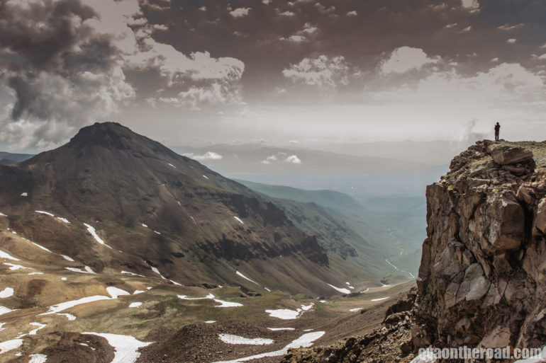
After less than 3 hours we are on the edge of a crater a little below the southern peak and the view takes our breath away. We admire the bottom of a huge volcanic pit covered with snow, all four peaks reaching four thousand meters, plains of coloured stones and green valley far away from us. Suddenly we realize,how helpless a little man is against nature. Unfortunatelyin the meantime, Ararat is hidden in the clouds, but that doesn’t bother us, because standing on the edge of the crater is such a powerful experience. We meet four hikers we saw before walking on the ridge, talk to them for a while, and they convince us that going to the western peak is a great idea. But as I see a mountain of loose rocks, it does not seem so great to me. But to overcome my first four-thousand attracts me.So we don’t go to the southern peak and go straight down the steep and rocky slope to a saddle below the western peak. We “only” have 200 altitude meters above us, but it seems to me like another thousand. In addition, I see our friends, who barely creep up and slow down with every step and the stones are pouring under their feet. Unfortunately, I give up the climb to the western peak. This time I will not humble my first four-thousand and I still regret not having tried. However, an advice for those who do not give up: do not go steeply up to the peak which you cansee from the saddle. It’s not the right peak. Stay more on the left. Then go down the same path and return to the lake along the contour around the southern peak. If you want to continue to the next peaks, you must always descend about 300 meters to the saddle (or crater itself) and then climb the same again. Rocks and debris are loosening and falling down, so be careful.


From the saddle between the southern and western peaks, we claw up through scree, which we have so laboriously descended down, and at least we reach the southern summit. There is a great view and the place is slowly filling up with tourists who headed up shortly after us. We admire a moment, but then the wind begins to blow unpleasantly, the clouds rush towards us and suddenly all the peaks disappear in them. It´s time to go down. We are returning the same way to the lake, which has come alive. A lot of people just drive to the parking lot, take a short walk around the lake and the weather station there, have lunch at a restaurant and go back to town. We have tea for warming up because the wind blowing by the lake is cold, and then we set out on our way back. After a few kilometres, we are changing jackets and pants for T-shirts and shorts and we are glad that we managed to climb the highest mountain in Armenia. Even though, only its lowest peak. We’ll keep the other ones for next time.

Aragats


Extra Tip
On your way down after some 18km, turn right on the asphalt road (this is the only turning, so you can’t miss it). After the next few kilometres it will take you to a 7th century Amberd Fort, which was built on a cliff above the confluence of the Amberd and Arkashen Rivers at 2,300 meters above sea level. The name Amberd means a fortress in the sky in Armenian, which suggests that there is a beautiful view of the entire plateauup to Yerevan. A little below the fortress stands a church and remains of a 13th-century spa and water tank. On the way to the fortress and the lake, you will see a lot of tents and huts, where sheep and goat herdsmen stay in summer.